
Thank you for supporting this site ❤️
Make a donation
Make a donation
Monte Judeu topographic map
Click on the map to display elevation.
Thank you for supporting this site ❤️
Make a donation
Make a donation
About this map
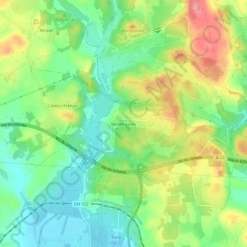
Name: Monte Judeu topographic map, elevation, terrain.
Location: Monte Judeu, Portimão, Faro, 8500-336, Portugal (37.16350 -8.59080 37.20350 -8.55080)
Average elevation: 40 m
Minimum elevation: -2 m
Maximum elevation: 97 m
Thank you for supporting this site ❤️
Make a donation
Make a donation
Other topographic maps
Click on a map to view its topography, its elevation and its terrain.