
Make a donation
Pinar del Rio topographic map
Click on the map to display elevation.
Make a donation
Pinar del Rio
The Pinar del Río province is Cuba's westernmost province and contains one of Cuba's three main mountain ranges, the Cordillera de Guaniguanico, divided into the easterly Sierra del Rosario and the westerly Sierra de los Órganos. These form a landscape characterised by steep sided limestone hills (called mogotes) and flat, fertile valleys. One such topographic feature, the Viñales Valley, is a UNESCO World Heritage Site.
Make a donation
About this map
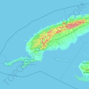
Name: Pinar del Rio topographic map, elevation, terrain.
Location: Pinar del Rio, Cuba (21.46914 -85.16797 23.14697 -82.92608)
Average elevation: 15 m
Minimum elevation: -2 m
Maximum elevation: 648 m
Make a donation
Other topographic maps
Click on a map to view its topography, its elevation and its terrain.
Havana
Cuba > Havana > La Habana Vieja
There are low hills on which the city lies rise gently from the waters of the straits. A noteworthy elevation is the 200-foot-high (60-meter) limestone ridge that slopes up from the east and culminates in the heights of La Cabaña and El Morro, the sites of Spanish fortifications overlooking the eastern bay.…
Average elevation: 30 m
Make a donation
Make a donation
Make a donation
Make a donation
Make a donation
Make a donation
Make a donation
Make a donation
Make a donation
Make a donation
Make a donation
Make a donation