
Make a donation
Loch Lubnaig topographic map
Click on the map to display elevation.
Make a donation
About this map
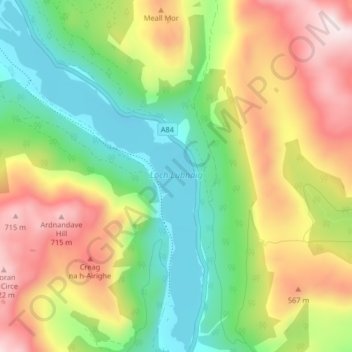
Name: Loch Lubnaig topographic map, elevation, terrain.
Location: Loch Lubnaig, Stirling, Scotland, United Kingdom (56.26552 -4.33197 56.31094 -4.28283)
Average elevation: 382 m
Minimum elevation: 110 m
Maximum elevation: 760 m
Make a donation
Other topographic maps
Click on a map to view its topography, its elevation and its terrain.
Make a donation
Ben A'an
United Kingdom > Scotland > Stirling
Ben A'an is a hill in the Trossachs in Scotland. The pointed peak of its west top (454 metres or 1,490 feet in elevation) resembles a small mountain.
Average elevation: 283 m
Make a donation
Loch Lomond and The Trossachs National Park
United Kingdom > Scotland > Stirling
The park straddles the Highland Boundary Fault, which divides it into two distinct regions - lowland and highland - that differ in underlying geology, soil types and topography. The change in rock type can most clearly be seen at Loch Lomond itself, as the fault runs across the islands of Inchmurrin, Creinch,…
Average elevation: 291 m
Make a donation
Make a donation
Make a donation
Make a donation
Make a donation
Make a donation
Make a donation
Make a donation
Make a donation
Make a donation
Make a donation
Make a donation
Make a donation
Make a donation
Make a donation
Make a donation
Make a donation
Make a donation