
Thank you for supporting this site ❤️
Make a donation
Make a donation
Lac Beauchamp topographic map
Click on the map to display elevation.
Thank you for supporting this site ❤️
Make a donation
Make a donation
About this map
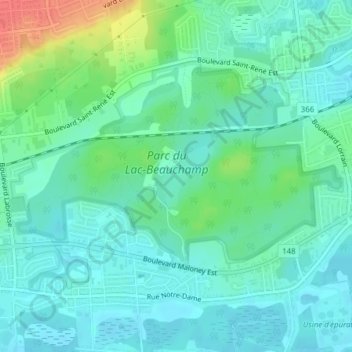
Name: Lac Beauchamp topographic map, elevation, terrain.
Location: Lac Beauchamp, Gatineau, Outaouais, Quebec, Canada (45.48769 -75.62348 45.49244 -75.61785)
Average elevation: 56 m
Minimum elevation: 42 m
Maximum elevation: 96 m
Thank you for supporting this site ❤️
Make a donation
Make a donation
Other topographic maps
Click on a map to view its topography, its elevation and its terrain.