
Thank you for supporting this site ❤️
Make a donation
Make a donation
Mount Guiwan topographic map
Click on the map to display elevation.
Thank you for supporting this site ❤️
Make a donation
Make a donation
Mount Guiwan
Mount Guiwan is a mountain in the Sierra Madre range in Alfonso Castañeda, Nueva Vizcaya, Philippines. It is probably the highest peak of Sierra Madre mountain range with a height of at least 1,915 metres (6,283 ft) above sea level according to NAMRIA topographic map and perhaps as high as 1,950 metres (6,400 ft). Bugkalots have long established trails which they use when hunting.
Thank you for supporting this site ❤️
Make a donation
Make a donation
About this map
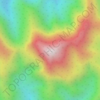
Name: Mount Guiwan topographic map, elevation, terrain.
Location: Mount Guiwan, Nueva Vizcaya, Cagayan Valley, Philippines (15.94523 121.28634 15.94533 121.28644)
Average elevation: 1,462 m
Minimum elevation: 1,056 m
Maximum elevation: 1,908 m
Thank you for supporting this site ❤️
Make a donation
Make a donation
Other topographic maps
Click on a map to view its topography, its elevation and its terrain.