
Make a donation
Kayapa topographic map
Click on the map to display elevation.
Make a donation
About this map
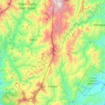
Name: Kayapa topographic map, elevation, terrain.
Location: Kayapa, Nueva Vizcaya, Cagayan Valley, Philippines (16.30470 120.82598 16.60373 121.02028)
Average elevation: 1,258 m
Minimum elevation: 380 m
Maximum elevation: 2,904 m
Make a donation
Other topographic maps
Click on a map to view its topography, its elevation and its terrain.
Make a donation
Make a donation
Mount Pulag
At lower elevations, Mount Pulag has a mossy forest full of ferns, lichens, and moss.
Average elevation: 2,572 m
Make a donation
Make a donation
Make a donation
Make a donation
Make a donation
Mount Guiwan
Mount Guiwan is a mountain in the Sierra Madre range in Alfonso Castañeda, Nueva Vizcaya, Philippines. It is probably the highest peak of Sierra Madre mountain range with a height of at least 1,915 metres (6,283 ft) above sea level according to NAMRIA topographic map and perhaps as high as 1,950 metres (6,400…
Average elevation: 1,462 m
Make a donation
Make a donation
Make a donation
Make a donation
Make a donation
Make a donation
Make a donation
Make a donation
Make a donation
Mount Pulag
Philippines > Nueva Vizcaya > Kayapa
At lower elevations, Mount Pulag has a mossy forest full of ferns, lichens, and moss.
Average elevation: 2,572 m
Mount Pulag
Philippines > Nueva Vizcaya > Kayapa
At lower elevations, Mount Pulag has a mossy forest full of ferns, lichens, and moss.
Average elevation: 2,572 m
Make a donation
Mount Pulag
Philippines > Nueva Vizcaya > Kayapa
At lower elevations, Mount Pulag has a mossy forest full of ferns, lichens, and moss.
Average elevation: 2,572 m