
Thank you for supporting this site ❤️
Make a donation
Make a donation
Sudwala Caves topographic map
Click on the map to display elevation.
Thank you for supporting this site ❤️
Make a donation
Make a donation
About this map
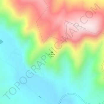
Name: Sudwala Caves topographic map, elevation, terrain.
Average elevation: 995 m
Minimum elevation: 810 m
Maximum elevation: 1,255 m
Thank you for supporting this site ❤️
Make a donation
Make a donation
Other topographic maps
Click on a map to view its topography, its elevation and its terrain.
Longmere Dam
South Africa > Mpumalanga > Ehlanzeni District Municipality > Mbombela > White River Country Estates
Average elevation: 963 m
Tekwane North
South Africa > Mpumalanga > Ehlanzeni District Municipality > Mbombela > eMankayana
Average elevation: 771 m
Klipkoppie Dam
South Africa > Mpumalanga > Ehlanzeni District Municipality > Mbombela
Average elevation: 973 m