
Make a donation
Alderney topographic map
Click on the map to display elevation.
Make a donation
About this map
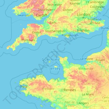
Name: Alderney topographic map, elevation, terrain.
Location: Alderney, Guernsey (47.11699 -4.79689 52.31699 0.40311)
Average elevation: 57 m
Minimum elevation: -2 m
Maximum elevation: 822 m
Make a donation
Other topographic maps
Click on a map to view its topography, its elevation and its terrain.
Guernsey
Situated in Mont Saint-Michel Bay at around 49°35′N 2°20′W / 49.583°N 2.333°W / 49.583; -2.333, Guernsey, Herm and some other smaller islands together have a total area of 71 square kilometres (27 sq mi) and coastlines of about 46 kilometres (29 mi). Elevation varies from sea level to 110 m…
Average elevation: 18 m
Make a donation
Guernsey
Situated in Mont Saint-Michel Bay at around 49°35′N 2°20′W / 49.583°N 2.333°W / 49.583; -2.333, Guernsey, Herm and some other smaller islands together have a total area of 71 square kilometres (27 sq mi) and coastlines of about 46 kilometres (29 mi). Elevation varies from sea level to 110 m…
Average elevation: 18 m
Make a donation
abreuvoir of Saint Peter Port and Saint Martins
Guernsey > Guernsey > St Peter Port
Average elevation: 60 m
Make a donation
Guernsey
Situated in Mont Saint-Michel Bay at around 49°35′N 2°20′W / 49.583°N 2.333°W / 49.583; -2.333, Guernsey, Herm and some other smaller islands together have a total area of 71 square kilometres (27 sq mi) and coastlines of about 46 kilometres (29 mi). Elevation varies from sea level to 110 m…
Average elevation: 18 m
abreuvoir of Saint Peter Port and Saint Martins
Guernsey > Guernsey > St Peter Port
Average elevation: 60 m
Make a donation
Make a donation
Make a donation