
North Sikkim District topographic map
Interactive map
Click on the map to display elevation.
About this map
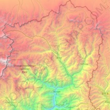
Name: North Sikkim District topographic map, elevation, terrain.
Location: North Sikkim District, Sikkim, India (27.37542 88.11250 28.12264 88.88812)
Average elevation: 4,407 m
Minimum elevation: 599 m
Maximum elevation: 8,458 m
Most of the people of the state reside near Mangan, the district headquarters which is about 2,000 feet (610 m) above sea level. Further north the elevation increases with the vegetation turning from temperate to alpine to tundra. Temperatures range from about 25° to below −40° in the extreme high reaches where the altitude is in excess of 6,000 metres. Kanchenjanga is the highest peak at over 8,000 m, straddling its western border with Nepal and can be seen clearly from the town of Singhik.
Other topographic maps
Click on a map to view its topography, its elevation and its terrain.
South Lhonak Glacier
India > Sikkim > Chungthang
South Lhonak Glacier, Chungthang, Mangan District, Sikkim, India
Average elevation: 5,830 m
Goecha La Lake
Goecha La Lake, Mangan, Mangan District, Sikkim, India
Average elevation: 4,953 m
Pakyong
India > Sikkim > Pakyong subdivision
Pakyong, Pakyong subdivision, Pakyong District, Sikkim, 737106, India
Average elevation: 1,235 m
Chungthang
Chungthang, North Sikkim District, Sikkim, 737120, India
Average elevation: 4,598 m
Lachung Chu
India > Sikkim > Chungthang > Lachung
Lachung Chu, Lachung, Chungthang, North Sikkim District, Sikkim, India
Average elevation: 4,332 m
North District
North District, North Sikkim District, Sikkim, India
Average elevation: 3,760 m
Lower Sichey
Lower Sichey, Gangtok, East Sikkim District, Sikkim, India
Average elevation: 1,352 m
West District
India > Sikkim > West District
West District, West Sikkim District, Sikkim, 737111, India
Average elevation: 2,636 m
East District
India > Sikkim > East District
East District, East Sikkim District, Sikkim, India
Average elevation: 2,740 m
Lachung
India > Sikkim > Chungthang
Lachung, Chungthang, Mangan District, Sikkim, India
Average elevation: 3,617 m
Western Sikkim Subsection
Western Sikkim Subsection, North District, North Sikkim District, Sikkim, India
Average elevation: 3,898 m
Upper Sichey
Upper Sichey, Gangtok, East Sikkim District, Sikkim, India
Average elevation: 1,459 m
Lower M G Marg
Lower M G Marg, Gangtok, East Sikkim District, Sikkim, 737101, India
Average elevation: 1,348 m
Teesta River
Teesta River, Namchi, South Sikkim District, Sikkim, 737132, India
Average elevation: 1,113 m
Pegong
India > Sikkim > Chungthang
Pegong, Chungthang, North Sikkim District, Sikkim, India
Average elevation: 1,950 m
Gurudongmar
India > Sikkim > Chungthang
Gurudongmar, Chungthang, North Sikkim District, Sikkim, India
Average elevation: 5,232 m
South District
India > Sikkim > South District
South District, South Sikkim District, Sikkim, 737139, India
Average elevation: 2,687 m
Zemu Glacier
Zemu Glacier, North District, North Sikkim District, Sikkim, India
Average elevation: 5,499 m
Khecheopalri Lake
Khecheopalri Lake, MDR, Yuksom, West District, West Sikkim District, Sikkim, 737113, India
Average elevation: 1,798 m
Tso Lhamo Lake
Tso Lhamo Lake, North District, North Sikkim District, Sikkim, India
Average elevation: 5,146 m