
Thank you for supporting this site ❤️
Make a donation
Make a donation
Pike River topographic map
Click on the map to display elevation.
Thank you for supporting this site ❤️
Make a donation
Make a donation
About this map
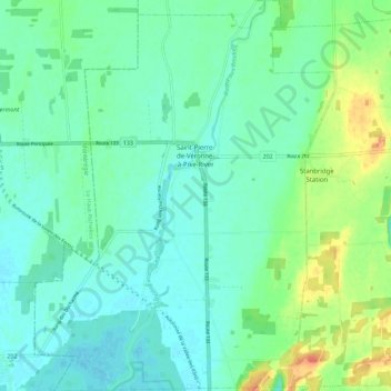
Name: Pike River topographic map, elevation, terrain.
Location: Pike River, Brome-Missisquoi, Estrie, Quebec, Canada (45.07469 -73.11562 45.15387 -73.02924)
Average elevation: 41 m
Minimum elevation: 28 m
Maximum elevation: 76 m
Thank you for supporting this site ❤️
Make a donation
Make a donation
Other topographic maps
Click on a map to view its topography, its elevation and its terrain.
Paradis-des-Chênes
Canada > Quebec > Brome-Missisquoi > Dunham > Paradis-des-Chênes
Average elevation: 167 m
Thank you for supporting this site ❤️
Make a donation
Make a donation