
Make a donation
Nairobi County topographic map
Click on the map to display elevation.
Make a donation
About this map
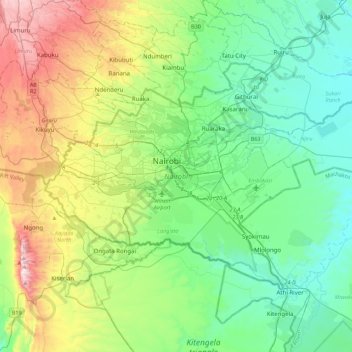
Name: Nairobi County topographic map, elevation, terrain.
Location: Nairobi County, Nairobi, Kenya (-1.44488 36.66470 -1.16067 37.10487)
Average elevation: 1,729 m
Minimum elevation: 1,456 m
Maximum elevation: 2,442 m
Make a donation
Other topographic maps
Click on a map to view its topography, its elevation and its terrain.
Make a donation
Nyeri
Kenya > Nyeri > Nyeri Central
Nyeri has tarmacked roads, and the county and national governments are upgrading many of them. Houses have drinking water on tap, but sewage provision is through soak pits, pit latrines and septic tanks are still widespread. The city's topography allows nature and gravity to take care of most of the city's…
Average elevation: 1,796 m
Ngong
As of 2019, the population of Ngong Town consisting of Enchorro-Emunyi and Ngong Township locations is 25,866. The elevation of Ngong town is 1,961 meters in altitude, but the altitude of the hills is about 2,460 meters above sea level. Ngong was the central town of Ngong division while Kajiado County was a…
Average elevation: 1,951 m
Make a donation