
Jiménez topographic map
Interactive map
Click on the map to display elevation.
About this map
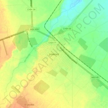
Name: Jiménez topographic map, elevation, terrain.
Location: Jiménez, Chihuahua, 33980, México (27.08562 -104.95186 27.16562 -104.87186)
Average elevation: 1,381 m
Minimum elevation: 1,363 m
Maximum elevation: 1,396 m
Other topographic maps
Click on a map to view its topography, its elevation and its terrain.
La Boquilla
La Boquilla, Jiménez, Chihuahua, México
Average elevation: 1,449 m