
Make a donation
Zhangjiajie topographic map
Click on the map to display elevation.
Make a donation
About this map
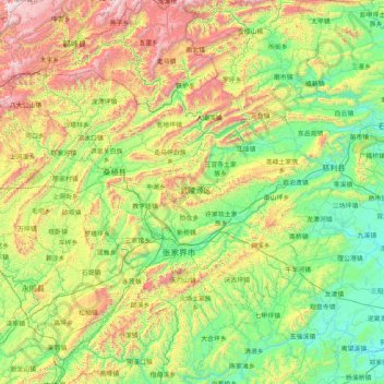
Name: Zhangjiajie topographic map, elevation, terrain.
Location: Zhangjiajie, Hunan, China (28.88391 109.69663 29.79210 111.33185)
Average elevation: 556 m
Minimum elevation: 38 m
Maximum elevation: 2,014 m
Make a donation
Other topographic maps
Click on a map to view its topography, its elevation and its terrain.
Make a donation
Make a donation
Make a donation
Make a donation
Make a donation
Make a donation
Ningxiang
China > Hunan > Ningxiang > Yutan Subdistrict
The highest natural elevation in Ningxiang County is 1071m at Wazizhai (瓦子寨).
Average elevation: 83 m
Make a donation
Zhangjiajie Tianmen Mountain National Forest Park
China > Hunan > Yongding District
Average elevation: 781 m
Make a donation
Make a donation
Make a donation
Xiangxi
China > Hunan > Jishou City > Zhenxi Subdistrict
Xiangxi Tujia and Miao Autonomous Prefecture is located in a low-latitude zone and has a humid subtropical monsoon climate. It is characterized by the influence of the topography of the Wuling Mountains: the winter is relatively cold, the summer temperature is high and humid, the spring and summer are wet and…
Average elevation: 542 m
Make a donation