
Batna topographic map
Interactive map
Click on the map to display elevation.
About this map
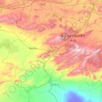
Name: Batna topographic map, elevation, terrain.
Location: Batna, Algeria (34.75362 4.74066 35.92275 6.79281)
Average elevation: 720 m
Minimum elevation: -25 m
Maximum elevation: 2,259 m
The origins of the name of the city and province of Batna are not clear, but most historians agree that it is of Arabic origin: m'batna, meaning: "Where we sleep this night". Capital of the highlands situated between the Tell Atlas in the north and the Saharan Atlas in the south, with the Chott el Hodna in the middle, it constitutes a naturally protected passage between south and north. Its climate is moderate, hot and dry during summer time, due to its altitude (it being 800 metres above sea level) the winter is tough, snowy and at times cold (with temperatures of -15 °C recorded on some cold winter nights). This geo-political position is the origin of the last economy merging city due to a high commercial exchange rate between the north's seaward opening, and the south's source of all the wealth of the country (including reserves of oil, natural gas, iron and many minerals).
Other topographic maps
Click on a map to view its topography, its elevation and its terrain.
Sebseb
Algeria > Ghardaia > Metlili Châamba District
Sebseb, Metlili Châamba District, Ghardaia, 47025, Algeria
Average elevation: 514 m
chebcheb
Algeria > Algiers > Rouiba District > Reghaia
chebcheb, Reghaia, Rouiba District, Algiers, 16036, Algeria
Average elevation: 24 m
Algiers
Algeria > Algiers > Sidi M'Hamed District > Alger-Centre
Algiers, Alger-Centre, Sidi M'Hamed District, Algiers, 16007, Algeria
Average elevation: 45 m
Gouraya
Algeria > Tipaza > Gouraya District
Gouraya, Gouraya District, Tipaza, 42007, Algeria
Average elevation: 309 m
Chahna
Algeria > Jijel > Taher District
Chahna, Taher District, Jijel, Algeria
Average elevation: 634 m
Zouitna
Algeria > Jijel > Chekfa District > El Kennar Nouchfi
Zouitna, El Kennar Nouchfi, Chekfa District, Jijel, 18030, Algeria
Average elevation: 45 m
Blida
Algeria > Blida > Blida District
Blida, Blida District, Blida, 09000, Algeria
Average elevation: 359 m
Cité les palmiers
Algeria > Algiers > Dar El Beïda > Cité les palmiers
Cité les palmiers, Dar El Beïda, Dar El Beida District, Algiers, 16100, Algeria
Average elevation: 19 m
Tizi Ouzou
Algeria > Tizi Ouzou > Tizi Ouzou
Tizi Ouzou, Tizi Ouzou District, Tizi Ouzou, 15000, Algeria
Average elevation: 345 m
Ain Temouchent
Algeria > Aïn Témouchent > Ain Temouchent
Ain Temouchent, Ain Temouchent District, Aïn Témouchent, 46000, Algeria
Average elevation: 333 m
Bejaia
Algeria > Bejaia > Bejaia District
Bejaia, Bejaia District, Bejaia, 06000, Algeria
Average elevation: 60 m
Khenchela
Algeria > Khenchela > Khenchela District
Khenchela, Khenchela District, Khenchela, Algeria
Average elevation: 1,116 m
Belouizdad
Algeria > Algiers > Belouizdad
Belouizdad, Hussein Dey District, Algiers, Algeria
Average elevation: 36 m
Dar El Beida District
Dar El Beida District, Algiers, Algeria
Average elevation: 14 m
Aït Laaziz
Algeria > Bouira > Aït Laaziz
Aït Laaziz, Bouïra District, Bouira, Algeria
Average elevation: 686 m
Chouf
Algeria > Bordj Bou Arreridj > Djaâfra District > Tafreg
Chouf, Tafreg, Djaâfra District, Bordj Bou Arreridj, Algeria
Average elevation: 980 m
Ali Mendjeli
Algeria > Constantine > El Khroub District
Ali Mendjeli, El Khroub, El Khroub District, Constantine, 25005, Algeria
Average elevation: 747 m