
Make a donation
Biosphere 2 Research Center topographic map
Click on the map to display elevation.
Make a donation
Biosphere 2 Research Center
The glass and spaceframe facility is located in Oracle, Arizona at the base of the Santa Catalina Mountains, about 50 minutes north of Tucson. Its elevation is around 4,000 feet (1,200 m) above sea level.
Make a donation
About this map
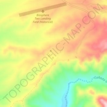
Name: Biosphere 2 Research Center topographic map, elevation, terrain.
Average elevation: 1,159 m
Minimum elevation: 1,039 m
Maximum elevation: 1,260 m
Make a donation
Other topographic maps
Click on a map to view its topography, its elevation and its terrain.
San Manuel
United States > Arizona > Pinal County
San Manuel is located at 32°36′18″N 110°38′0″W / 32.60500°N 110.63333°W / 32.60500; -110.63333 (32.605048, -110.633340), in the San Pedro River Valley at an elevation of about 3,500 feet (1,100 m). San Manuel is approximately 45 miles (72 km) northeast of Tucson.
Average elevation: 991 m
Kearny
United States > Arizona > Pinal County
Kearny Airport is a general aviation airport located in the southern section of the town. In 2003 it received the Arizona Department of Transportation's Airport of the Year award. The airport has a single asphalt runway, 3,400 feet (1,000 m) in length and 60 feet (18 m) in width, with a field elevation of…
Average elevation: 578 m
Make a donation
Make a donation