
Thank you for supporting this site ❤️
Make a donation
Make a donation
Duck Corral Tank topographic map
Click on the map to display elevation.
Thank you for supporting this site ❤️
Make a donation
Make a donation
About this map
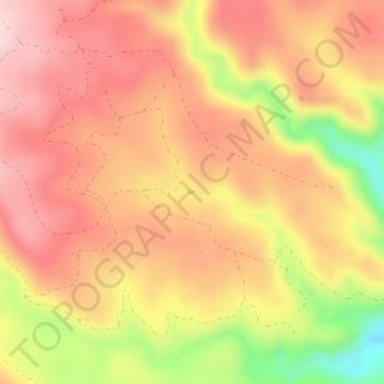
Name: Duck Corral Tank topographic map, elevation, terrain.
Location: Duck Corral Tank, Greenlee County, Arizona, United States (33.74847 -109.18467 33.74882 -109.18403)
Average elevation: 2,391 m
Minimum elevation: 2,224 m
Maximum elevation: 2,484 m
Thank you for supporting this site ❤️
Make a donation
Make a donation
Other topographic maps
Click on a map to view its topography, its elevation and its terrain.