
Ngọc Lặc District topographic map
Interactive map
Click on the map to display elevation.
About this map
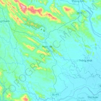
Name: Ngọc Lặc District topographic map, elevation, terrain.
Location: Ngọc Lặc District, Thanh Hoá Province, Vietnam (19.92035 105.24576 20.21622 105.51001)
Average elevation: 104 m
Minimum elevation: 6 m
Maximum elevation: 914 m
Other topographic maps
Click on a map to view its topography, its elevation and its terrain.
Triệu Sơn District
Triệu Sơn District, Thanh Hoá Province, Vietnam
Average elevation: 35 m