
Thank you for supporting this site ❤️
Make a donation
Make a donation
Chacalluta topographic map
Click on the map to display elevation.
Thank you for supporting this site ❤️
Make a donation
Make a donation
About this map
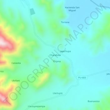
Name: Chacalluta topographic map, elevation, terrain.
Location: Chacalluta, Macari, Province of Melgar, Puno, Peru (-14.81459 -70.90963 -14.77459 -70.86963)
Average elevation: 4,029 m
Minimum elevation: 3,930 m
Maximum elevation: 4,408 m
Thank you for supporting this site ❤️
Make a donation
Make a donation