
Make a donation
Hinterschmiding topographic map
Click on the map to display elevation.
Make a donation
Hinterschmiding
In Hinterschmiding wird das kulturelle Leben in vielerlei Form gepflegt, ob Bildende Kunst, Literatur oder Musik, es ist für jeden etwas dabei, speziell die Partnerschaft mit dem Chor der Universität Ostrava bringt immer wieder Höhepunkte im musikalischen Bereich.
Make a donation
About this map
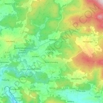
Name: Hinterschmiding topographic map, elevation, terrain.
Average elevation: 757 m
Minimum elevation: 565 m
Maximum elevation: 1,105 m
Make a donation
Other topographic maps
Click on a map to view its topography, its elevation and its terrain.
Make a donation
Hörmannsberg
Deutschland > Bayern > Landkreis Freyung-Grafenau > Grafenau > Heinrichsreit
Average elevation: 613 m
Make a donation
Sankt Oswald
Deutschland > Bayern > Landkreis Freyung-Grafenau > Sankt Oswald-Riedlhütte
Average elevation: 731 m
Kaltenberg
Deutschland > Bayern > Landkreis Freyung-Grafenau > Grafenau > Großarmschlag
Average elevation: 684 m
Make a donation
Mitternachmühle
Deutschland > Bayern > Landkreis Freyung-Grafenau > Schönberg > Mitternach
Average elevation: 497 m
Make a donation
Lusen
Deutschland > Bayern > Landkreis Freyung-Grafenau > Neuschönau
Der Lusen (tschechisch Luzný) ist mit seiner Höhe von 1373 m ü. NHN nach dem Großen Arber, Großen Rachel, Kleinen Rachel und Kleinen Arber der fünfthöchste Berg im Bayerischen Wald / Böhmerwald. Er liegt wie auch der Rachel und der Große Falkenstein im Nationalpark Bayerischer Wald dicht an der Grenze…
Average elevation: 1,210 m
Frischeck
Deutschland > Bayern > Landkreis Freyung-Grafenau > Waldkirchen > Ratzing
Average elevation: 612 m
Stadl
Deutschland > Bayern > Landkreis Freyung-Grafenau > Waldkirchen > Auerbach
Average elevation: 579 m
Make a donation
Traxing
Deutschland > Bayern > Landkreis Freyung-Grafenau > Waldkirchen > Ratzing
Average elevation: 567 m
Geyersberg
Deutschland > Bayern > Landkreis Freyung-Grafenau > Freyung
Im Bereich der Ortslage befand sich ursprünglich mit dem Burgstall Geyersberg eine abgegangene mittelalterliche Höhenburg, die Sitz der Passauer Bischöfe war und sich in der Gegenwart unter Bodendenkmalschutz befindet.
Average elevation: 620 m
Stocking
Deutschland > Bayern > Landkreis Freyung-Grafenau > Waldkirchen > Stocking
Average elevation: 650 m
Make a donation
Klingenbrunn
Deutschland > Bayern > Landkreis Freyung-Grafenau
Das etwa 950 Einwohner zählende Pfarrdorf liegt in einer Höhenlage von 820 Metern an der Straße zwischen Frauenau und Spiegelau.
Average elevation: 785 m
Make a donation
Make a donation
Paulusmühle
Deutschland > Bayern > Landkreis Freyung-Grafenau > Steinerleinbach
Average elevation: 470 m
Oberfrauenwald
Deutschland > Bayern > Landkreis Freyung-Grafenau > Waldkirchen
Average elevation: 720 m
Make a donation
Make a donation
Neuhäusl
Deutschland > Bayern > Landkreis Freyung-Grafenau > Mitterfirmiansreut
Average elevation: 949 m
Make a donation
Duschlberg
Deutschland > Bayern > Landkreis Freyung-Grafenau > Hinterfreundorf
Average elevation: 855 m
Pittersberg
Deutschland > Bayern > Landkreis Freyung-Grafenau > Freyung > Grillaberg
Average elevation: 663 m
Make a donation
Make a donation
Kühn
Deutschland > Bayern > Landkreis Freyung-Grafenau > Waldkirchen > Oberhöhenstetten
Average elevation: 487 m
Make a donation
Neidlingerberg
Deutschland > Bayern > Landkreis Freyung-Grafenau > Waldkirchen > Holzfreyung
Average elevation: 697 m
Make a donation
Finsterau
Deutschland > Bayern > Landkreis Freyung-Grafenau
Finsterau ist ein etwa 1.000 Meter über Meereshöhe gelegenes Dorf in der Gemeinde Mauth im Landkreis Freyung-Grafenau im Bayerischen Wald an der Grenze zu Tschechien. Die Gemarkung Finsterau umfasst die Orte Finsterau und Heinrichsbrunn.
Average elevation: 934 m
Schönbrunn
Deutschland > Bayern > Landkreis Freyung-Grafenau > Freyung > Oberndorf
Average elevation: 674 m
Make a donation
Make a donation
Haslach
Deutschland > Bayern > Landkreis Freyung-Grafenau > Sankt Oswald-Riedlhütte
Average elevation: 707 m
Make a donation
Mittlerer Daxstein
Deutschland > Bayern > Landkreis Freyung-Grafenau > Zenting
Average elevation: 740 m
Make a donation
Maukenreuth
Deutschland > Bayern > Landkreis Freyung-Grafenau > Schönberg > Mitternach
Average elevation: 489 m
Branntweinhäuser
Deutschland > Bayern > Landkreis Freyung-Grafenau > Hinterfreundorf
Average elevation: 827 m
Make a donation
Kreuzstraße
Deutschland > Bayern > Landkreis Freyung-Grafenau > Freyung > Ahornöd
Average elevation: 686 m
Make a donation
Dreisessel
Deutschland > Bayern > Landkreis Freyung-Grafenau > Neureichenau
Vom Dreisesselberg führt der Höhenzug Hochkamm über den Bayerischen Plöckenstein (1365 m ü. NHN) und über das Dreiländereck Deutschland-Österreich-Tschechien (1321 m) zum an der österreichisch-tschechischen Grenze gelegenen Hauptgipfel des Plöckensteins (1378,3 m). Er verläuft entlang der…
Average elevation: 1,148 m
Brotjacklriegel
Deutschland > Bayern > Landkreis Freyung-Grafenau > Schöfweg
Der Brotjacklriegel ist – von der Donau aus gesehen – mit seinen 1011 m ü. NHN Höhe der erste größere Berg im Bayerischen Wald. Der Berg liegt im Landkreis Freyung-Grafenau und stellt ein Wahrzeichen der Region Sonnenwald mit den Gemeinden Schöfweg, Zenting, Innernzell, Grattersdorf und dem Markt…
Average elevation: 802 m
Make a donation
Unterhöhenstetten
Deutschland > Bayern > Landkreis Freyung-Grafenau > Waldkirchen
Average elevation: 492 m
Make a donation
Reisersberg
Deutschland > Bayern > Landkreis Freyung-Grafenau > Auggenthal > Reisersberg
Average elevation: 499 m
Heindlmühle
Deutschland > Bayern > Landkreis Freyung-Grafenau > Wasching > Heindlmühle
Average elevation: 589 m
Make a donation
Plattenhausenriegel
Deutschland > Bayern > Landkreis Freyung-Grafenau > Sankt Oswald
Über den Plattenhausenriegel (tschechisch Blatný vrch) im Bayerischen Wald läuft die Grenze des Landkreises Freyung-Grafenau in Bayern zu Tschechien, er liegt zwischen dem Großen Rachel (1453 m) im Westnordwesten und dem Lusen (1373 m) im Südosten und ist nach der aktuellen Topographischen Karte Bayerns…
Average elevation: 1,217 m
Make a donation