
Thank you for supporting this site ❤️
Make a donation
Make a donation
Harmony Beach topographic map
Click on the map to display elevation.
Thank you for supporting this site ❤️
Make a donation
Make a donation
About this map
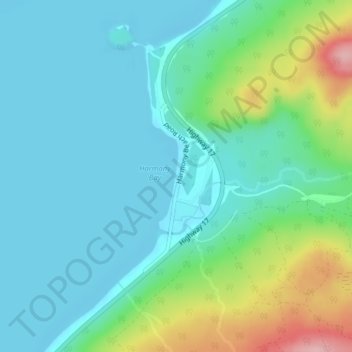
Name: Harmony Beach topographic map, elevation, terrain.
Average elevation: 217 m
Minimum elevation: 178 m
Maximum elevation: 343 m
Thank you for supporting this site ❤️
Make a donation
Make a donation
Other topographic maps
Click on a map to view its topography, its elevation and its terrain.
Thank you for supporting this site ❤️
Make a donation
Make a donation
Kabinakagami Lake
Canada > Ontario > Algoma District > Unorganized North Algoma
Average elevation: 332 m
Thank you for supporting this site ❤️
Make a donation
Make a donation
Thank you for supporting this site ❤️
Make a donation
Make a donation
Kimiwan Creek;Kimiwan Lakes
Canada > Ontario > Algoma District > Unorganized North Algoma
Average elevation: 442 m
Thank you for supporting this site ❤️
Make a donation
Make a donation
Montreal Island
Canada > Ontario > Algoma District > Unorganized North Algoma
Average elevation: 190 m
Thank you for supporting this site ❤️
Make a donation
Make a donation
Kabinakagamisis Lake
Canada > Ontario > Algoma District > Unorganized North Algoma
Average elevation: 324 m
Thank you for supporting this site ❤️
Make a donation
Make a donation