
Thank you for supporting this site ❤️
Make a donation
Make a donation
Mels topographic map
Click on the map to display elevation.
Thank you for supporting this site ❤️
Make a donation
Make a donation
About this map
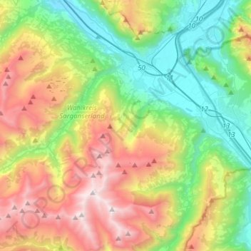
Name: Mels topographic map, elevation, terrain.
Location: Mels, Wahlkreis Sarganserland, Saint-Gall, 8887, Suisse (46.92702 9.23628 47.08138 9.48523)
Average elevation: 1,317 m
Minimum elevation: 442 m
Maximum elevation: 2,801 m
Thank you for supporting this site ❤️
Make a donation
Make a donation
Other topographic maps
Click on a map to view its topography, its elevation and its terrain.