
Make a donation
Narrows Wash topographic map
Click on the map to display elevation.
Make a donation
About this map
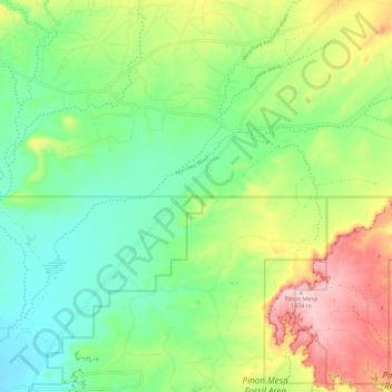
Name: Narrows Wash topographic map, elevation, terrain.
Location: Narrows Wash, San Juan County, New Mexico, United States (36.82181 -108.37598 36.87883 -108.26223)
Average elevation: 1,708 m
Minimum elevation: 1,610 m
Maximum elevation: 1,883 m
Make a donation
Other topographic maps
Click on a map to view its topography, its elevation and its terrain.
Navajo Lake State Park
United States > New Mexico > San Juan County > Navajo Dam
Average elevation: 1,966 m
Make a donation
Make a donation
Aztec
United States > New Mexico > San Juan County > Aztec > Aztec
Yet another area managed by the BLM, this area was formed about the same time as the Bisti and Ah-Shi-Sle-Pah. This region offers a uniquely different scale of landscape. Hoodoo in this region are massive and the terrain much greater in elevation differences, thereby exposing a greater geological time frame…
Average elevation: 1,767 m
Make a donation