
Thank you for supporting this site ❤️
Make a donation
Make a donation
Bloomfield topographic map
Click on the map to display elevation.
Thank you for supporting this site ❤️
Make a donation
Make a donation
About this map
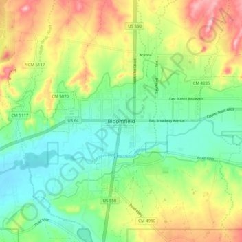
Name: Bloomfield topographic map, elevation, terrain.
Location: Bloomfield, San Juan County, New Mexico, United States (36.67112 -108.02451 36.75112 -107.94451)
Average elevation: 1,701 m
Minimum elevation: 1,640 m
Maximum elevation: 1,801 m
Thank you for supporting this site ❤️
Make a donation
Make a donation
Other topographic maps
Click on a map to view its topography, its elevation and its terrain.
Lake Farmington Recreation Area
United States > New Mexico > San Juan County > Farmington
Average elevation: 1,723 m
Navajo Lake State Park
United States > New Mexico > San Juan County > Navajo Dam
Average elevation: 1,966 m
Thank you for supporting this site ❤️
Make a donation
Make a donation