
Krachtighuizen topographic map
Interactive map
Click on the map to display elevation.
About this map
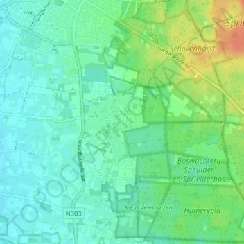
Name: Krachtighuizen topographic map, elevation, terrain.
Average elevation: 21 m
Minimum elevation: 10 m
Maximum elevation: 48 m
Other topographic maps
Click on a map to view its topography, its elevation and its terrain.
Gerven
Nederland > Gelderland > Putten
Gerven, Putten, Gelderland, Nederland, 3882 LW, Nederland
Average elevation: 13 m
Strand Nulde Noord
Nederland > Gelderland > Putten
Strand Nulde Noord, Putten, Gelderland, Nederland
Average elevation: 1 m
Strand Nulde Noord
Nederland > Gelderland > Putten
Strand Nulde Noord, Putten, Gelderland, Nederland
Average elevation: 1 m