
Make a donation
Uruguay topographic map
Click on the map to display elevation.
Make a donation
Uruguay
Located entirely within the southern temperate zone, Uruguay has a climate that is relatively mild and fairly uniform nationwide. According to the Köppen Climate Classification, most of the country has a humid subtropical climate (Cfa). Only in some spots of the Atlantic Coast and at the summit of the highest hills of the Cuchilla Grande the climate is oceanic (Cfb). The country experiences the four seasons, with summer being from December to March and winter from June to September. Seasonal variations are pronounced, but extremes in temperature are rare. Summers are tempered by winds off the Atlantic, and severe cold in winter is unknown. Although it never gets too cold, frosts occur every year during the winter months, and precipitation such as sleet and graupel occur almost every winter, but snow is very rare; it does occur every couple of years at higher elevations, but almost always without accumulation. As would be expected with its abundance of water, high humidity and fog are common. The absence of mountains, which act as weather barriers, makes all locations vulnerable to high winds and rapid changes in weather as fronts or storms sweep across the country. These storms can be strong; they can bring squalls, hail, and sometimes even tornadoes. The country experiences extratropical cyclones but no tropical cyclones, due to the fact that the South Atlantic Ocean is rarely warm enough for their development. Both summer and winter weather may vary from day to day with the passing of storm fronts, where a hot northerly wind may occasionally be followed by a cold wind (pampero) from the Argentine Pampas.
Make a donation
About this map
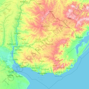
Name: Uruguay topographic map, elevation, terrain.
Location: Uruguay (-35.78248 -58.49477 -30.08540 -53.07558)
Average elevation: 83 m
Minimum elevation: -4 m
Maximum elevation: 485 m
Make a donation
Other topographic maps
Click on a map to view its topography, its elevation and its terrain.
Make a donation
Africa
Africa's topography is a complex tapestry of plateaus, mountains, valleys, and deserts. The continent is dominated by vast plateaus, with elevations averaging around 1,000 meters (3,281 feet), especially prominent in the south and east. The Ethiopian Highlands, often referred to as the "Roof of Africa," rise…
Average elevation: 462 m
Make a donation
Make a donation
Fort Canning Park
The hill has a long history intertwined with that of the country due to its location as the highest elevation within walking distance to the city's civic district, within the Downtown Core. It is also a popular location for exhibitions, concerts, and outdoor recreation.
Average elevation: 19 m
Make a donation
Marie Byrd Land
Adjacent to the continent, Marie Byrd Land is bordered by the Amundsen Sea in the east and the Ross Sea and Ross Ice Shelf in the west. Mountain ranges are prominent along and near the coastline with a few exceptions. Marie Byrd Land is covered by the vast West Antarctic Ice Sheet (WAIS). The WAIS in Marie…
Average elevation: 921 m
Make a donation
Lindridge Park
United Kingdom > England > Devon > Teignbridge > Luton > Humber
Average elevation: 125 m
Make a donation
Vikos–Aoos National Park
Greece > Epirus > Ioannina Regional Unit
The Vikos–Aoös National Park (Greek: Εθνικός Δρυμός Βίκου–Αώου, romanized: Ethnikós Drymós Víkou–Aóou) is a national park in the region of Epirus in northwestern Greece. The park, founded in 1973, is one of ten national parks in mainland Greece and is located 30 kilometres (19…
Average elevation: 1,147 m
Make a donation
Make a donation
Debre Markos
Ethiopia > Amhara Region > Guzamn
Debre Markos is located 300 km north-west of Addis Ababa along the Addis Ababa-Gondar road at an elevation of over 2400 meters.
Average elevation: 2,343 m
Bsharri
Bsharri (Arabic: بشرّي Bšarrī; also romanized Becharre, Bcharre, Bsharre, Bcharre Al Arz) is a Lebanese town located in the district of the same name, North Governorate, situated at altitudes between 1,100 m (3,600 ft) and 3,088 m (10,131 ft). Bsharri is the location of the Cedars of God, a UNESCO World…
Average elevation: 1,847 m
Make a donation
Make a donation
Make a donation
Make a donation
Make a donation
Make a donation
Kotdwar
India > Uttarakhand > Kotdwara
Kotdwar lies on the western margin of the Himalayas, at an altitude of 454 m (1,490 ft) above sea level.
Average elevation: 641 m
Make a donation
Sinabad
Iran > West Azerbaijan Province > Urumia County > دهستان صومای جنوبی
Average elevation: 1,876 m
Make a donation
Make a donation
Aramoun
Lebanon > Mount Lebanon Governorate
Aramoun (Arabic: عرمون) is a village in the Aley District of Mount Lebanon, Lebanon, lying to the east of Khalde and 22 kilometres away from Beirut. Aramoun's altitude ranges between 250 meters to 600 meters further east. The village has a Druze and Christian community, major families are Yehia, Jawhari,…
Average elevation: 467 m
Corró d'Amunt
Spain > Catalonia > Vallès Oriental > les Franqueses del Vallès
Average elevation: 287 m
Make a donation
Pièce du Moulin
France > Nouvelle-Aquitaine > Charente-Maritime > Le Grand-Village-Plage
Average elevation: 4 m
Make a donation
Make a donation
Make a donation
Make a donation
San Jose
The municipality is in a valley bounded on the east by the Palusong Mountain Range moving south and on the west by the Hitaasan Mountain Range. The land is generally alluvial flat and swamplands which has an elevation of less than 10 metres (33 ft) above sea level, while going south, south easterly, the…
Average elevation: 15 m
Make a donation
Make a donation
Make a donation