
Make a donation
Harare topographic map
Click on the map to display elevation.
Make a donation
Harare
Harare (/həˈrɑːreɪ/ hə-RAR-ay), formerly known as Salisbury (/ˈsɔːlzbəri/ SAWLZ-bər-ee), is the capital and largest city of Zimbabwe, and is the most populous city in the country. The city proper has an area of 982.3km2 (378.7 mi2), a population of 1,849,600 as of the 2022 census and an estimated 2,487,209 people in its metropolitan province. The city is situated in north-eastern Zimbabwe in the country's Mashonaland region. Harare is a metropolitan province, which also incorporates the municipalities of Chitungwiza and Epworth. The city sits on a plateau at an elevation of 1,483 metres (4,865 feet) above sea level, and its climate falls into the subtropical highland category.
Make a donation
About this map
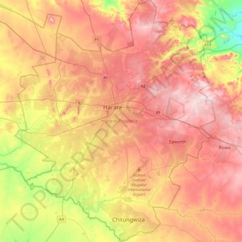
Name: Harare topographic map, elevation, terrain.
Location: Harare, Zimbabwe (-18.05099 30.87743 -17.65716 31.22145)
Average elevation: 1,461 m
Minimum elevation: 1,281 m
Maximum elevation: 1,603 m
Make a donation
Other topographic maps
Click on a map to view its topography, its elevation and its terrain.
Marondera
Zimbabwe > Mashonaland East Province > Marondera
Marondera is situated on the highveld plateau, and has a subtropical highland climate (Köppen Cwb). The city enjoys a sunny climate, with the summer months (October to April) characterised by warm to hot days followed by afternoon thundershowers and cool evenings, and the winter months (May to September) by…
Average elevation: 1,637 m