
Make a donation
Proppo topographic map
Click on the map to display elevation.
Make a donation
About this map
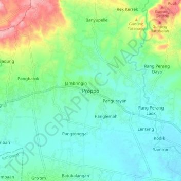
Name: Proppo topographic map, elevation, terrain.
Location: Proppo, Pamekasan, East Java, Java, Indonesia (-7.16378 113.36967 -7.08378 113.44967)
Average elevation: 61 m
Minimum elevation: 19 m
Maximum elevation: 178 m
Make a donation
Other topographic maps
Click on a map to view its topography, its elevation and its terrain.
Make a donation
Sidoarjo
Administratively, Sidoarjo Regency is divided into 18 districts, 28 urban villages (kelurahan), and 318 rural villages (desa). The most densely populated districts are located in the northern part, such as Waru and Taman, which serve as gateways to Surabaya and centers of urbanization. Meanwhile, coastal areas…
Average elevation: 59 m
Make a donation
Malang
Indonesia > East Java > Kota Malang
The city was capital city of Singhasari in 1222, then transferred to Dutch colony. Malang was modernized under the Dutch; its mild climate which results from its elevation, along with its proximity to the major port of Surabaya, made it a popular destination for the Dutch and other Europeans. Malang began to…
Average elevation: 490 m
Make a donation
Make a donation
Malang
Indonesia > East Java > Kota Malang
The city was capital city of Singhasari in 1222, then transferred to Dutch colony. Malang was modernized under the Dutch; its mild climate which results from its elevation, along with its proximity to the major port of Surabaya, made it a popular destination for the Dutch and other Europeans. Malang began to…
Average elevation: 490 m
Sidoarjo
Administratively, Sidoarjo Regency is divided into 18 districts, 28 urban villages (kelurahan), and 318 rural villages (desa). The most densely populated districts are located in the northern part, such as Waru and Taman, which serve as gateways to Surabaya and centers of urbanization. Meanwhile, coastal areas…
Average elevation: 59 m
Make a donation
Make a donation
Make a donation
Make a donation
Make a donation
Suaka Margasatwa Dataran Tinggi Yang
Indonesia > East Java > Probolinggo > Situbondo
Average elevation: 1,885 m
Make a donation
Make a donation
Make a donation
Make a donation
Malang
The city was capital city of Singhasari in 1222, then transferred to Dutch colony. Malang was modernized under the Dutch; its mild climate which results from its elevation, along with its proximity to the major port of Surabaya, made it a popular destination for the Dutch and other Europeans. Malang began to…
Average elevation: 490 m
Make a donation
Make a donation
Make a donation
Make a donation
Blitar
Blitar is a landlocked city in East Java, Indonesia, about 73 km from Malang and 167 km from Surabaya. The area lies within longitude 111° 40' – 112° 09' East and its latitude is 8° 06' South. The city of Blitar lies at an altitude on average 167 metres above sea level, and is an enclave within Blitar…
Average elevation: 180 m
Make a donation
Make a donation
Malang
Indonesia > East Java > Kota Malang
The city was capital city of Singhasari in 1222, then transferred to Dutch colony. Malang was modernized under the Dutch; its mild climate which results from its elevation, along with its proximity to the major port of Surabaya, made it a popular destination for the Dutch and other Europeans. Malang began to…
Average elevation: 490 m
Make a donation
Make a donation
Make a donation
Make a donation
Make a donation
Malang
Indonesia > East Java > Kota Malang
The city was capital city of Singhasari in 1222, then transferred to Dutch colony. Malang was modernized under the Dutch; its mild climate which results from its elevation, along with its proximity to the major port of Surabaya, made it a popular destination for the Dutch and other Europeans. Malang began to…
Average elevation: 490 m
Make a donation