
Thank you for supporting this site ❤️
Make a donation
Make a donation
Middlegate topographic map
Click on the map to display elevation.
Thank you for supporting this site ❤️
Make a donation
Make a donation
About this map
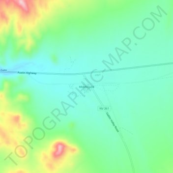
Name: Middlegate topographic map, elevation, terrain.
Location: Middlegate, Churchill County, Nevada, United States (39.26721 -118.04720 39.30721 -118.00720)
Average elevation: 1,443 m
Minimum elevation: 1,379 m
Maximum elevation: 1,601 m
Thank you for supporting this site ❤️
Make a donation
Make a donation
Other topographic maps
Click on a map to view its topography, its elevation and its terrain.
Dixie Valley - Fairview Peak 7.1 Earthquake 1954 Fault Line
United States > Nevada > Churchill County
Average elevation: 1,817 m