
Make a donation
Quebrada Seca topographic map
Click on the map to display elevation.
Make a donation
About this map
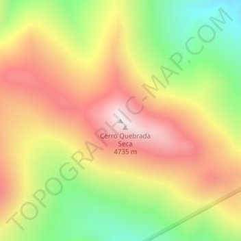
Name: Quebrada Seca topographic map, elevation, terrain.
Location: Quebrada Seca, Iglesia, San Juan, Argentina (-29.62699 -69.35845 -29.62689 -69.35835)
Average elevation: 4,334 m
Minimum elevation: 3,896 m
Maximum elevation: 4,734 m
Make a donation
Other topographic maps
Click on a map to view its topography, its elevation and its terrain.
Calingasta
Calingasta has a rugged, mountainous topography due to its location at the foot of the Andes. Mount Mercedario is the eighth-highest mountain of the Andes with an altitude of 6,720 metres (22,050 ft). It is located 100 kilometres (62 mi) north of Aconcagua. The precordillera range is the Sierra del Tontal,…
Average elevation: 2,393 m
Ischigualasto Provincial Park
Most of the park lies within the Valle Fértil Department, with a minor part in the Jachal Department of San Juan, at an altitude of about 1,300 m (4,300 ft) amsl. The park is part of the western border of the Central Sierras, and features typical desert vegetation (bushes, cacti and some trees) which covers…
Average elevation: 1,258 m
Make a donation
Ischigualasto Provincial Park
Most of the park lies within the Valle Fértil Department, with a minor part in the Jachal Department of San Juan, at an altitude of about 1,300 m (4,300 ft) amsl. The park is part of the western border of the Central Sierras, and it features typical desert vegetation (bushes, cacti and some trees) which…
Average elevation: 1,258 m