
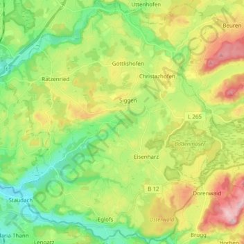
Argenbühl topographic map
Interactive map
Click on the map to display elevation.
About this map
Name: Argenbühl topographic map, elevation, terrain.
Average elevation: 673 m
Minimum elevation: 566 m
Maximum elevation: 847 m
Other topographic maps
Click on a map to view its topography, its elevation and its terrain.
Leutkirch
Allemagne > Bade-Wurtemberg > Landkreis Ravensburg > Leutkirch im Allgäu
Leutkirch, Leutkirch im Allgäu, Verwaltungsgemeinschaft Leutkirch im Allgäu, Landkreis Ravensburg, Bade-Wurtemberg, 88299, Allemagne
Average elevation: 671 m
Badhaus
Allemagne > Bade-Wurtemberg > Landkreis Ravensburg > Boos > Badhaus
Badhaus, Boos, Ebersbach-Musbach, Verwaltungsverband Altshausen, Landkreis Ravensburg, Bade-Wurtemberg, 88371, Allemagne
Average elevation: 638 m
Bad Wurzach
Allemagne > Bade-Wurtemberg > Landkreis Ravensburg
Bad Wurzach, Landkreis Ravensburg, Bade-Wurtemberg, 88410, Allemagne
Average elevation: 679 m