
Bad Wurzach topographic map
Interactive map
Click on the map to display elevation.
About this map
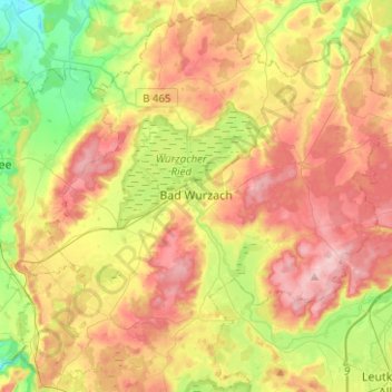
Name: Bad Wurzach topographic map, elevation, terrain.
Average elevation: 679 m
Minimum elevation: 573 m
Maximum elevation: 789 m
La municipalité de Bad Wurzach se trouve dans une plaine qui s'étend entre les régions de l'Allgäu et de Haute-Souabe, sur le bord du Wurzacher Ried. Son altitude par rapport au niveau de la mer varie entre 650 et 800 mètres.
Other topographic maps
Click on a map to view its topography, its elevation and its terrain.
Argenbühl
Allemagne > Bade-Wurtemberg > Landkreis Ravensburg
Argenbühl, Landkreis Ravensburg, Bade-Wurtemberg, 88260, Allemagne
Average elevation: 673 m
Leutkirch
Allemagne > Bade-Wurtemberg > Landkreis Ravensburg > Leutkirch im Allgäu
Leutkirch, Leutkirch im Allgäu, Verwaltungsgemeinschaft Leutkirch im Allgäu, Landkreis Ravensburg, Bade-Wurtemberg, 88299, Allemagne
Average elevation: 671 m
Badhaus
Allemagne > Bade-Wurtemberg > Landkreis Ravensburg > Boos > Badhaus
Badhaus, Boos, Ebersbach-Musbach, Verwaltungsverband Altshausen, Landkreis Ravensburg, Bade-Wurtemberg, 88371, Allemagne
Average elevation: 638 m