
Ebbw Vale topographic map
Interactive map
Click on the map to display elevation.
About this map
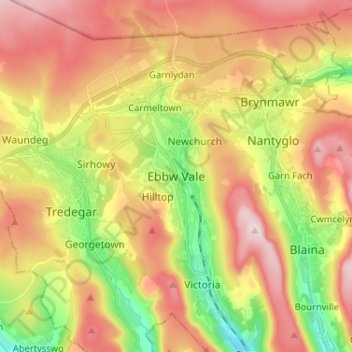
Name: Ebbw Vale topographic map, elevation, terrain.
Average elevation: 384 m
Minimum elevation: 208 m
Maximum elevation: 550 m
Ebbw Vale liegt – auf gut 200 Metern Höhe – in Südwales in den South Wales Valleys im Tal des Ebbw Fawr River. Die Stadt erstreckt sich über mehr als vier Kilometer in Nord-Süd-Ausrichtung vom Anfang des Tals in den Heads of the Valleys bis zu ihrem Ende auf Höhe des Berges Briery Hill. Dabei umfasst sie neben Ebbw Vale die Stadtteile Beaufort, Carmeltown, Garnlydan, Glyncoed, Hilltop, Mountain Air, Newchurch, Newtown, Rassau und Willowtown. Das Gebiet ist untergliedert in fünf Communitys: Badminton, Beaufort und Rassau im Norden sowie im Südteil der Stadt Ebbw Vale North und Ebbw Vale South. Die Stadt liegt östlich von Tredegar, westlich von Nantyglo und westlich bis südwestlich von Brynmawr. Als Built-up area sub division bildet Ebbw Vale zudem zusammen mit Brynmawr, Nantyglo und dem südöstlich der Stadt gelegenen Blaina die Ebbw Vale Built-up area.
Other topographic maps
Click on a map to view its topography, its elevation and its terrain.
Cefn Manmoel - Y Domen Fawr
Vereinigtes Königreich > Wales > Blaenau Gwent County Borough > Ebbw Vale
Cefn Manmoel - Y Domen Fawr, Ebbw Vale, Blaenau Gwent County Borough, Wales, NP22 4NJ, Vereinigtes Königreich
Average elevation: 346 m