
Thank you for supporting this site ❤️
Make a donation
Make a donation
Castle Rock State Park topographic map
Click on the map to display elevation.
Thank you for supporting this site ❤️
Make a donation
Make a donation
About this map
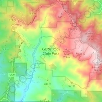
Name: Castle Rock State Park topographic map, elevation, terrain.
Average elevation: 578 m
Minimum elevation: 225 m
Maximum elevation: 984 m
Thank you for supporting this site ❤️
Make a donation
Make a donation
Other topographic maps
Click on a map to view its topography, its elevation and its terrain.
Thank you for supporting this site ❤️
Make a donation
Make a donation
Thank you for supporting this site ❤️
Make a donation
Make a donation
Pleasure Point
United States > California > Santa Cruz County > Pleasure Point
Average elevation: 12 m
Huckleberry Woods
United States > California > Santa Cruz County > Boulder Creek
Average elevation: 263 m
Thank you for supporting this site ❤️
Make a donation
Make a donation
The Vineyard
United States > California > Santa Cruz County > Bonny Doon > The Vineyard
Average elevation: 426 m
Thank you for supporting this site ❤️
Make a donation
Make a donation