
Hoorn topographic map
Interactive map
Click on the map to display elevation.
About this map
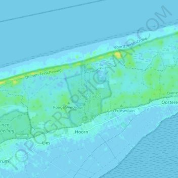
Name: Hoorn topographic map, elevation, terrain.
Location: Hoorn, Terschelling, Friesland, Niederlande (53.38487 5.32591 53.43041 5.36414)
Average elevation: 2 m
Minimum elevation: -4 m
Maximum elevation: 16 m
Other topographic maps
Click on a map to view its topography, its elevation and its terrain.
Terschelling
Niederlande > Friesland > Terschelling
Terschelling, Friesland, Niederlande
Average elevation: 0 m
Baaiduinen
Niederlande > Friesland > Terschelling
Baaiduinen, Terschelling, Friesland, Niederlande
Average elevation: 2 m
Formerum
Niederlande > Friesland > Terschelling
Formerum, Terschelling, Friesland, Niederlande
Average elevation: 0 m