
Addison (Webster Springs) topographic map
Interactive map
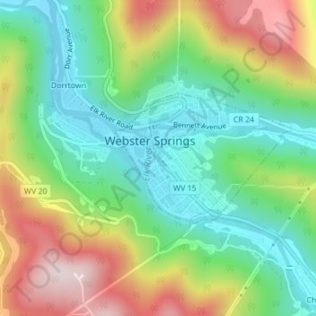
Click on the map to display elevation.
About this map
Name: Addison (Webster Springs) topographic map, elevation, terrain.
Average elevation: 602 m
Minimum elevation: 431 m
Maximum elevation: 878 m
Webster Springs is located at 38°28′34″N 80°24′36″W / 38.47611°N 80.41000°W / 38.47611; -80.41000 (38.476192, -80.410025), along the Elk River. According to the United States Census Bureau, the town has a total area of 0.47 square miles (1.22 km2), of which 0.45 square miles (1.17 km2) is land and 0.02 square miles (0.05 km2) is water. It lies at an elevation of 1,460 ft. (445m) and is close to Buffalo Bull Knob, elevation 2,799 ft.
Other topographic maps
Click on a map to view its topography, its elevation and its terrain.
Diana
United States > West Virginia > Webster County
Diana, Webster County, West Virginia, 26217, United States
Average elevation: 553 m
Hacker Valley
United States > West Virginia > Webster County
Hacker Valley, Webster County, West Virginia, 26222, United States
Average elevation: 582 m
Cowen
United States > West Virginia > Webster County
Cowen, Webster County, West Virginia, 26206, United States
Average elevation: 709 m
Holly River State Park
United States > West Virginia > Webster County
Holly River State Park, Webster County, West Virginia, United States
Average elevation: 674 m
Big Ditch Lake
United States > West Virginia > Webster County
Big Ditch Lake, Webster County, West Virginia, United States
Average elevation: 708 m