
Big Ditch Lake topographic map
Interactive map
Click on the map to display elevation.
About this map
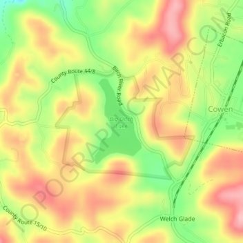
Name: Big Ditch Lake topographic map, elevation, terrain.
Location: Big Ditch Lake, Webster County, West Virginia, United States (38.40337 -80.57576 38.41293 -80.56906)
Average elevation: 708 m
Minimum elevation: 627 m
Maximum elevation: 774 m
Other topographic maps
Click on a map to view its topography, its elevation and its terrain.
Diana
United States > West Virginia > Webster County
Diana, Webster County, West Virginia, 26217, United States
Average elevation: 553 m
Hacker Valley
United States > West Virginia > Webster County
Hacker Valley, Webster County, West Virginia, 26222, United States
Average elevation: 582 m
Cowen
United States > West Virginia > Webster County
Cowen, Webster County, West Virginia, 26206, United States
Average elevation: 709 m
Addison (Webster Springs)
United States > West Virginia > Webster County
Addison (Webster Springs), Webster County, West Virginia, 26288, United States
Average elevation: 602 m
Holly River State Park
United States > West Virginia > Webster County
Holly River State Park, Webster County, West Virginia, United States
Average elevation: 674 m