
Make a donation
Nagpur topographic map
Click on the map to display elevation.
Make a donation
Nagpur
Nagpur is located at the exact centre of the Indian subcontinent, close to the geometric centre of the quadrilateral connecting the four major metros of India, viz. Chennai, Mumbai, New Delhi and Kolkata. The city has the Zero Mile Stone locating the geographical centre of India, which was used by the British to measure all distances within the Indian subcontinent. The city lies on the Deccan plateau of the Indian subcontinent and has a mean altitude of 310.5 meters above sea level. The underlying rock strata are covered with alluvial deposits resulting from the flood plain of the Kanhan River. In some places, these give rise to granular sandy soil. In low-lying areas, which are poorly drained, the soil is alluvial clay with poor permeability characteristics. In the eastern part of the city, crystalline metamorphic rocks such as gneiss, schist and granites are found, while in the northern part yellowish sandstones and clays of the lower Gondwana formations are found. Nagpur city is dotted with natural and artificial lakes. The largest lake is Ambazari Lake. Other natural lakes include Gorewada Lake and Telankhedi lake. Sonegaon and Gandhisagar Lakes are artificial, created by the city's historical rulers. Nag river, Pilli Nadi, and nallas form the natural drainage pattern for the city. Nagpur is known for its greenery and was adjudged the cleanest and second greenest in India after Chandigarh in 2010.
Make a donation
About this map
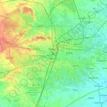
Name: Nagpur topographic map, elevation, terrain.
Location: Nagpur, Maharashtra, India (21.05297 78.99522 21.23100 79.17885)
Average elevation: 309 m
Minimum elevation: 274 m
Maximum elevation: 389 m
Make a donation
Other topographic maps
Click on a map to view its topography, its elevation and its terrain.
Pimpri-Chinchwad
India > Maharashtra > Haveli
Pimpri-Chinchwad also known as "PCMC", is a city in the Indian state of Maharashtra. The city is about 15 km (9.3 mi) northwest of the historic city of Pune, at an altitude of 590 m (1,940 ft) above sea level. It is the fifth largest city in Maharashtra and the nineteenth largest city in India and the…
Average elevation: 605 m
Make a donation
Make a donation
Solapur
India > Maharashtra > Solapur North
Solapur is located at 17°41′N 75°55′E / 17.68°N 75.92°E / 17.68; 75.92. It has an average elevation of 458 metres (1502 feet). It is bordered by Ahmednagar district on the north; Osmanabad district on the north and northeast.
Average elevation: 469 m
Make a donation
Make a donation
Make a donation
Make a donation
Make a donation
Make a donation
Make a donation
Make a donation
Make a donation
Make a donation
Make a donation
Make a donation
Make a donation
Make a donation
Make a donation
Make a donation
Goregaon
India > Maharashtra > Mangaon Taluka
Goregaon is located in the south-west of India at 18°10′N 73°18′E / 18.17°N 73.3°E / 18.17; 73.3. The average elevation is 28 metres (92 ft).
Average elevation: 38 m
Make a donation
Make a donation
Malkapur
India > Maharashtra > Shahuwadi
Malkapur is located at 16°56′N 73°55′E / 16.93°N 73.92°E / 16.93; 73.92. It has an average elevation of 586 metres (1922 feet).
Average elevation: 581 m
Make a donation
अमरावती
Amravati is located at 20°56′N 77°45′E / 20.93°N 77.75°E / 20.93; 77.75. It has an average elevation of 343 meters (1125 feet). It lies 156 km (97 mi) west of Nagpur and serves as the administrative centre of Amravati District and of Amravati Division. The city is located near the passes…
Average elevation: 421 m
Make a donation
Make a donation
Make a donation
Pench (Indira Priyadarsini) National Park/Tiger Reserve
India > Maharashtra > Ramtek Taluka
Average elevation: 485 m
Make a donation