
Make a donation
Monmouth County topographic map
Click on the map to display elevation.
Make a donation
Monmouth County
In 1910, the Wright Brothers hosted an aviation show in Interlaken, where numerous records were broken, such as high altitudes, longest time airborne, the first night flight, and the first air mail delivery.
Make a donation
About this map
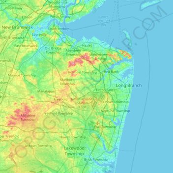
Name: Monmouth County topographic map, elevation, terrain.
Location: Monmouth County, New Jersey, United States (40.07914 -74.61364 40.51910 -73.90214)
Average elevation: 19 m
Minimum elevation: -3 m
Maximum elevation: 111 m
Make a donation
Other topographic maps
Click on a map to view its topography, its elevation and its terrain.
North Hudson Park
United States > New Jersey > Hudson County > North Bergen > Hudson Heights
Average elevation: 41 m
Make a donation
Pleasant Valley
United States > New Jersey > Morris County > Mendham Township
Average elevation: 156 m
Make a donation
East Trenton Heights
United States > New Jersey > Mercer County > Hamilton Township
Average elevation: 22 m
Lake Parsippany
United States > New Jersey > Morris County > Parsippany-Troy Hills
Average elevation: 93 m
Make a donation
North Stelton
United States > New Jersey > Middlesex County > Piscataway Township
Average elevation: 29 m
Make a donation
Randolphville
United States > New Jersey > Middlesex County > Piscataway Township
Average elevation: 26 m
Randolphville
United States > New Jersey > Middlesex County > Piscataway Township
Average elevation: 26 m
Paulas Corners
United States > New Jersey > Middlesex County > East Brunswick Township
Average elevation: 29 m
Make a donation
Lawrence Brook Manor
United States > New Jersey > Middlesex County > East Brunswick Township
Average elevation: 19 m
Robinsville
United States > New Jersey > Monmouth County > Upper Freehold Township
Average elevation: 56 m
Croxton
United States > New Jersey > Hudson County > Jersey City > Journal Square
Average elevation: 16 m
Make a donation
Wertsville
United States > New Jersey > Hunterdon County > East Amwell Township
Average elevation: 72 m
Possumtown
United States > New Jersey > Middlesex County > Piscataway Township
Average elevation: 19 m
Homes Mills
United States > New Jersey > Monmouth County > Upper Freehold Township
Average elevation: 34 m
Make a donation
Charleston East
United States > New Jersey > Camden County > Cherry Hill Township
Average elevation: 23 m
Van Marters Corner
United States > New Jersey > Monmouth County > Hazlet Township
Average elevation: 6 m
Make a donation
Make a donation
Basking Ridge
United States > New Jersey > Somerset County > Bernards Township
Average elevation: 98 m
Make a donation
Stow Acres
United States > New Jersey > Burlington County > Evesham Township > Marlton
Average elevation: 24 m
Make a donation
Woolwich Township
United States > New Jersey > Gloucester County > Woolwich Township
Average elevation: 23 m
Make a donation
Make a donation
Make a donation
Rahway River West Branch
United States > New Jersey > Essex County > Short Hills
Average elevation: 73 m
Make a donation
Columbia Lakes
United States > New Jersey > Camden County > Cherry Hill Township
Average elevation: 17 m
Remsterville
United States > New Jersey > Salem County > Alloway Township > Alloway Township
Average elevation: 15 m
Make a donation
Powder Mill Pond Dam
United States > New Jersey > Morris County > Parsippany-Troy Hills > Tabor
Average elevation: 178 m
Upper Mill
United States > New Jersey > Burlington County > Pemberton Township
Average elevation: 31 m
Make a donation
Freneau Woods Park
United States > New Jersey > Monmouth County > Aberdeen Township > Henningers Mill
Average elevation: 23 m
Make a donation
Mount Royal
United States > New Jersey > Gloucester County > East Greenwich Township
Average elevation: 11 m
Lincoln
United States > New Jersey > Gloucester County > South Harrison Township
Average elevation: 37 m
Make a donation
Washington Corner
United States > New Jersey > Morris County > Mendham Township
Average elevation: 174 m
Make a donation
Fostertown
United States > New Jersey > Burlington County > Lumberton Township
Average elevation: 14 m
Elmer B Boyd Park
United States > New Jersey > Middlesex County > New Brunswick > Feaster Park
Average elevation: 22 m
Make a donation
Make a donation
Make a donation
Make a donation
Schooleys Mountain
United States > New Jersey > Morris County > Washington Township
Average elevation: 293 m
Make a donation