
Make a donation
Brandon Peak topographic map
Click on the map to display elevation.
Make a donation
About this map
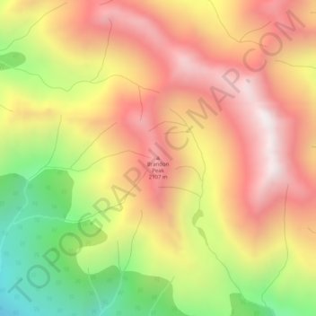
Name: Brandon Peak topographic map, elevation, terrain.
Average elevation: 1,801 m
Minimum elevation: 1,200 m
Maximum elevation: 2,267 m
Make a donation
Other topographic maps
Click on a map to view its topography, its elevation and its terrain.
Jack Lake
Canada > British Columbia > Peace River Regional District > Area B (Finlay Valley/Beatton Valley)
Average elevation: 996 m
Inga Lake
Canada > British Columbia > Peace River Regional District > Area B (Finlay Valley/Beatton Valley)
Average elevation: 865 m
Obo Lake
Canada > British Columbia > Peace River Regional District > Area B (Finlay Valley/Beatton Valley)
Average elevation: 1,300 m
Buckinghorse River
Canada > British Columbia > Peace River Regional District > Area B (Finlay Valley/Beatton Valley)
Average elevation: 945 m
Make a donation
Milligan Hills Provincial Park
Canada > British Columbia > Peace River Regional District > Area B (Finlay Valley/Beatton Valley)
Average elevation: 875 m
Charlie Lake
Canada > British Columbia > Peace River Regional District > Area B (Finlay Valley/Beatton Valley)
Average elevation: 761 m
Buckinghorse River
Canada > British Columbia > Peace River Regional District > Area B (Finlay Valley/Beatton Valley)
Average elevation: 1,200 m