Geolocate

Khovd topographic map

Click on the map to display elevation.

About this map

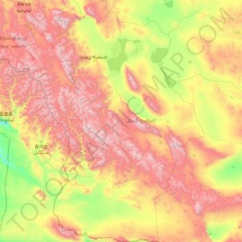
Name: Khovd topographic map, elevation, terrain.

Location: Khovd, Mongolia (44.99941 90.66776 48.96884 94.30683)

Average elevation: 1,804 m

Minimum elevation: 811 m

Maximum elevation: 4,193 m

Other topographic maps

Click on a map to view its topography, its elevation and its terrain.

Uyench

Mongolia > Khovd > Üyench

Average elevation: 1,433 m

Bayan-Ovoo

Mongolia > Ömnögovi > Bayan-Ovoo

Average elevation: 1,192 m

Bayangol

Mongolia > Selenge > Bayangol

Average elevation: 835 m

Ulaankhus

Mongolia > Bayan-Ölgii > Ulaankhus

Average elevation: 1,787 m

Nalaikh

Mongolia

Average elevation: 1,472 m

Gobi Desert

Mongolia > Ömnögovi > Khanbogd

Average elevation: 1,173 m

Choibalsan

Mongolia > Dornod > Kherlen

Choibalsan (Mongolian: Чойбалсан) is the fourth-largest city in Mongolia after Ulaanbaatar, Darkhan, and Erdenet. The name of the city was Bayan Tümen (Баян Түмэн) until 1941, when it was renamed after the communist leader Khorloogiin Choibalsan in honor of the 20th anniversary of the…

Average elevation: 764 m

talbai

Mongolia > Ulaanbaatar

Average elevation: 1,357 m

Gorkhi-Terelj National Park

Mongolia

Average elevation: 1,659 m

Отгонтэнгэр

Mongolia > Zavkhan > Aldarkhaan

Otgontenger (/ˌɒtɡɒnˈtɛŋɡər/; Mongolian: Отгонтэнгэр [ˈɔʰtχɞɴtʰɪŋɡɪ̆r]; lit. 'The Youngest Sky') is the highest peak in the Khangai Mountains in Mongolia. Its summit is currently calculated to reach an elevation of 4,010 meters above mean sea level (some earlier topographic…

Average elevation: 3,397 m

Khagiin khar Lake

Mongolia > Töv > Erdene

Average elevation: 1,884 m

Choir

Mongolia > Govisumber > Sumber

Average elevation: 1,283 m

Gorkhi-Terelj National Park

Mongolia

Average elevation: 1,659 m

Undurshil

Mongolia > Dundgovi > Öndörshil

Average elevation: 1,184 m

Zuunbayan

Mongolia > Dornogovi > Sainshand

Average elevation: 762 m

Khyalganat

Mongolia > Bulgan > Khangal

Average elevation: 797 m

Sergelen

Mongolia > Töv > Sergelen

Average elevation: 1,483 m

Chono kharaikhiin gol

Mongolia > Khovd > Dörgön

Average elevation: 1,196 m

Zuunmod

Mongolia > Töv > Zuunmod

Average elevation: 1,576 m

Terelj

Mongolia > Ulaanbaatar

Average elevation: 1,604 m

Flaming Cliffs

Mongolia > Ömnögovi > Bulgan

Average elevation: 1,220 m

Gobi Desert

Mongolia > Ömnögovi > Khanbogd

Average elevation: 1,173 m

Nomgon

Mongolia > Ömnögovi > Nomgon

Average elevation: 1,501 m

Khovsgol

Mongolia > Dornogovi > Khovsgol

Average elevation: 1,005 m

Nogoonnuur

Mongolia > Bayan-Ölgii > Nogoonnuur

Average elevation: 1,496 m

Zamiin uud

Mongolia > Dornogovi > Zamiin uud

Average elevation: 962 m

River

Mongolia > Ulaanbaatar

Average elevation: 1,443 m

Delgerkhangai

Mongolia > Dundgovi > Delgerkhangai

Average elevation: 1,486 m

Mandal-Ovoo

Mongolia > Ömnögovi > Mandal-Ovoo

Average elevation: 1,084 m

Erdenet

Mongolia > Orkhon > Bayan-Ondor

Average elevation: 1,370 m

Unit

Mongolia > Bulgan > Khutag-Undur

Average elevation: 1,236 m

Khangal Lake

Mongolia > Khentii > Ömnödelger

Average elevation: 1,350 m

Noyon

Mongolia > Ömnögovi > Noyon

Average elevation: 1,888 m

Ganga lake

Mongolia > Sükhbaatar > Dariganga

Average elevation: 1,298 m

Ongi River

Mongolia > Övörkhangai > Zuunbayan-Ulaan

Average elevation: 2,026 m

Choir

Mongolia > Govisumber > Sumber

Choir lies in the Choir Depression, a lowland strip about 150 km long and 10 to 20 km wide, about 500 m lower than the surrounding upland. It lies at an altitude of 1269 m.

Average elevation: 1,282 m

Battsengel

Mongolia > Arkhangai > Battsengel

Average elevation: 1,447 m

Bayandalai

Mongolia > Ömnögovi

Average elevation: 1,560 m

Central

Mongolia

Average elevation: 1,332 m

Хан-Уул

Mongolia > Dornod > Bulgan

Average elevation: 860 m

Ulaanbaatar

Mongolia > Ulaanbaatar > Ulaanbaatar

Ulaanbaatar (/ˌuːlɑːn ˈbɑːtər/; Mongolian: Улаанбаатар, , lit. "Red Hero"), previously anglicized as Ulan Bator, is the capital and most populous city of Mongolia. The municipality is located in north central Mongolia at an elevation of about 1,300 metres (4,300 ft) in a valley on the Tuul…

Average elevation: 1,541 m

Choibalsan

Mongolia > Dornod > Herlen > Choibalsan

Average elevation: 775 m

Ölgii

Mongolia > Bayan-Ölgii > Olgii > Ölgii

Average elevation: 2,063 m

Khangal

Mongolia > Bulgan > Hangal

Average elevation: 1,076 m

Chuluut

Mongolia > Arkhangai > Chuluut

Average elevation: 2,096 m

Erdenetsagaan

Mongolia > Sükhbaatar > Erdenetsagaan

Average elevation: 1,096 m

Bulgan

Mongolia > Ömnögovi > Bulgan

Average elevation: 1,305 m