
Nus topographic map
Interactive map
Click on the map to display elevation.
About this map
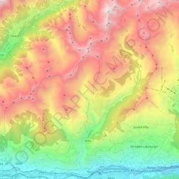
Name: Nus topographic map, elevation, terrain.
Location: Nus, Aosta Valley, Italy (45.73517 7.42918 45.87929 7.54664)
Average elevation: 1,851 m
Minimum elevation: 460 m
Maximum elevation: 3,487 m
Other topographic maps
Click on a map to view its topography, its elevation and its terrain.
Clavon
Italy > Aosta Valley > Verrayes > Clavon
Clavon, Verrayes, Aosta Valley, Italy
Average elevation: 1,574 m
Courmayeur
Italy > Aosta Valley > Courmayeur
Courmayeur, Aosta Valley, 11013, Italy
Average elevation: 2,367 m
Valtournenche
Italy > Aosta Valley > Valtournenche
Valtournenche, Aosta Valley, Italy
Average elevation: 2,640 m
Dent d'Hérens
Italy > Aosta Valley > Bionaz
Dent d'Hérens, Bionaz, Aosta Valley, Italy
Average elevation: 3,354 m