
Tongren topographic map
Interactive map
Click on the map to display elevation.
About this map
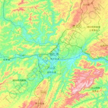
Name: Tongren topographic map, elevation, terrain.
Location: Tongren, Bijiang, 铜仁市, Guizhou, 558000, Chine (27.57473 109.02521 27.89473 109.34521)
Average elevation: 499 m
Minimum elevation: 229 m
Maximum elevation: 1,021 m
Other topographic maps
Click on a map to view its topography, its elevation and its terrain.
拉赖
Chine > Guizhou > Préfecture autonome buyei et miao de Qiannan > 拉赖
拉赖, Préfecture autonome buyei et miao de Qiannan, Guizhou, 558000, Chine
Average elevation: 968 m
长吉镇
Chine > Guizhou > Préfecture autonome miao et dong de Qiandongnan > 长吉镇
长吉镇, Préfecture autonome miao et dong de Qiandongnan, Guizhou, Chine
Average elevation: 657 m