
Thank you for supporting this site ❤️
Make a donation
Make a donation
Praz Coutant topographic map
Click on the map to display elevation.
Thank you for supporting this site ❤️
Make a donation
Make a donation
About this map
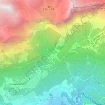
Name: Praz Coutant topographic map, elevation, terrain.
Average elevation: 1,415 m
Minimum elevation: 601 m
Maximum elevation: 2,598 m
Thank you for supporting this site ❤️
Make a donation
Make a donation
Other topographic maps
Click on a map to view its topography, its elevation and its terrain.
Refuge Le Châtelet d'Ayères
France > Auvergne-Rhône-Alpes > Haute-Savoie > Passy > Plaine Joux
Average elevation: 1,408 m
Thank you for supporting this site ❤️
Make a donation
Make a donation