
Parc national de Kahurangi topographic map
Interactive map
Click on the map to display elevation.
About this map
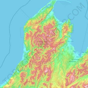
Name: Parc national de Kahurangi topographic map, elevation, terrain.
Location: Parc national de Kahurangi, West Coast, Nouvelle-Zélande (-41.78847 171.99280 -40.50769 172.92143)
Average elevation: 338 m
Minimum elevation: -1 m
Maximum elevation: 1,906 m
Other topographic maps
Click on a map to view its topography, its elevation and its terrain.
Mount Russel
Nouvelle-Zélande > West Coast > Westland District
Mount Russel, Westland District, West Coast, Nouvelle-Zélande
Average elevation: 1,384 m
Amherst Glacier
Nouvelle-Zélande > West Coast > Westland District
Amherst Glacier, Westland District, West Coast, Nouvelle-Zélande
Average elevation: 1,819 m
Franz Josef
Nouvelle-Zélande > West Coast > Westland District > Franz Josef / Waiau
Franz Josef, Fox Glacier Highway, Franz Josef / Waiau, Westland District, West Coast, 7856, Nouvelle-Zélande
Average elevation: 159 m
Southern Alps / Kā Tiritiri o te Moana
Southern Alps / Kā Tiritiri o te Moana, West Coast, Nouvelle-Zélande
Average elevation: 771 m
Greymouth
Nouvelle-Zélande > West Coast > Grey District
Greymouth, Grey District, West Coast, 7801, Nouvelle-Zélande
Average elevation: 40 m