
Elton topographic map
Click on the map to display elevation.
About this map
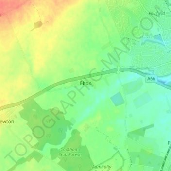
Name: Elton topographic map, elevation, terrain.
Location: Elton, Stockton-on-Tees, Tees Valley, England, United Kingdom (54.53015 -1.41379 54.56822 -1.35303)
Average elevation: 31 m
Minimum elevation: 12 m
Maximum elevation: 58 m
Other topographic maps
Click on a map to view its topography, its elevation and its terrain.
Stockton-on-Tees
United Kingdom > England > Stockton-on-Tees > Stockton-on-Tees
Average elevation: 17 m
Stockton-on-Tees
United Kingdom > England > Stockton-on-Tees > Stockton-on-Tees
Average elevation: 20 m
Six Fields Nature Reserve
United Kingdom > England > Stockton-on-Tees > Stockton-on-Tees
Average elevation: 18 m