
Make a donation
Shrewsbury topographic map
Click on the map to display elevation.
Make a donation
About this map
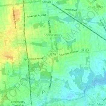
Name: Shrewsbury topographic map, elevation, terrain.
Average elevation: 11 m
Minimum elevation: -1 m
Maximum elevation: 26 m
Make a donation
Other topographic maps
Click on a map to view its topography, its elevation and its terrain.
Mount Pleasant
United States > New Jersey > Monmouth County > Marlboro Township
Average elevation: 58 m
Chapel Hill
United States > New Jersey > Monmouth County > Middletown Township
Average elevation: 27 m
Make a donation
Stone Tavern
United States > New Jersey > Monmouth County > Upper Freehold Township
Average elevation: 62 m
Make a donation
Sommers Boy Scout Park
United States > New Jersey > Monmouth County > Oceanport > Sands Point
Average elevation: 2 m
Navesink
United States > New Jersey > Monmouth County > Middletown Township > Navesink
Average elevation: 27 m
Freehold
United States > New Jersey > Monmouth County > Freehold Borough > Freehold
Freehold has an elevation of 174 feet (53 m) above sea level at its center.
Average elevation: 45 m
Make a donation
Make a donation
Make a donation
Ellisdale
United States > New Jersey > Monmouth County > Upper Freehold Township
Average elevation: 34 m
Lafayette Mills
United States > New Jersey > Monmouth County > Manalapan Township
Average elevation: 36 m
Make a donation
Make a donation
North Middletown
United States > New Jersey > Monmouth County > Middletown Township
Average elevation: 4 m
Sandy Hook Lighthouse
United States > New Jersey > Monmouth County > Fort Hancock
Average elevation: 1 m
Make a donation
Make a donation
Glendola
United States > New Jersey > Monmouth County > Wall Township > Glendola
Average elevation: 22 m
Stonehurst West
United States > New Jersey > Monmouth County > Freehold Township
Average elevation: 46 m
Make a donation