
Make a donation
Robertsville topographic map
Click on the map to display elevation.
Make a donation
About this map
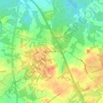
Name: Robertsville topographic map, elevation, terrain.
Average elevation: 39 m
Minimum elevation: 17 m
Maximum elevation: 60 m
Make a donation
Other topographic maps
Click on a map to view its topography, its elevation and its terrain.
Jersey Shore Region
United States > New Jersey > Monmouth County > Wall Township
Average elevation: 16 m
Oakhurst
United States > New Jersey > Monmouth County > Ocean Township
According to the United States Census Bureau, the CDP had a total area of 1.614 square miles (4.178 km2), including 1.611 square miles (4.171 km2) of land and 0.003 square miles (0.006 km2) of water (0.16%). The CDP also has an elevation of 46 feet above sea level.
Average elevation: 15 m
Leonardo
United States > New Jersey > Monmouth County > Middletown Township > Leonardo
Average elevation: 6 m
Make a donation
Sommers Boy Scout Park
United States > New Jersey > Monmouth County > Oceanport > Sands Point
Average elevation: 2 m
Make a donation
Navesink
United States > New Jersey > Monmouth County > Middletown Township > Navesink
Average elevation: 27 m
Make a donation
Port Monmouth
United States > New Jersey > Monmouth County > Middletown Township
Average elevation: 3 m
Make a donation