
Thank you for supporting this site ❤️
Make a donation
Make a donation
Haldensleben topographic map
Click on the map to display elevation.
Thank you for supporting this site ❤️
Make a donation
Make a donation
About this map
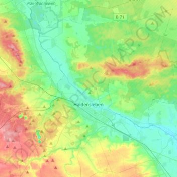
Name: Haldensleben topographic map, elevation, terrain.
Location: Haldensleben, Börde, Саксония-Анхальт, 39340, Германия (52.22680 11.26284 52.38637 11.55067)
Average elevation: 81 m
Minimum elevation: 45 m
Maximum elevation: 153 m
Thank you for supporting this site ❤️
Make a donation
Make a donation
Other topographic maps
Click on a map to view its topography, its elevation and its terrain.