
Make a donation
Langzhong City topographic map
Click on the map to display elevation.
Make a donation
Langzhong City
Langzhong is located in the northeast of the province and the northern part of the Sichuan Basin on the middle reaches of the Jialing River. Within the city's administrative area, elevations generally increase from southwest to northeast and range from 328 metres (1,076 ft) to 888 metres (2,913 ft), while rivers flow for 59.4 kilometres (36.9 mi). The area is dominated by low-lying mountains and hills.
Make a donation
About this map
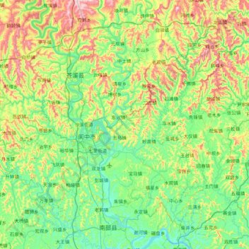
Name: Langzhong City topographic map, elevation, terrain.
Location: Langzhong City, Nanchong, Sichuan, China (31.36485 105.68243 31.85154 106.42046)
Average elevation: 480 m
Minimum elevation: 313 m
Maximum elevation: 927 m
Make a donation
Other topographic maps
Click on a map to view its topography, its elevation and its terrain.
Make a donation
Make a donation
Make a donation
Make a donation
Make a donation
Make a donation
Make a donation
Make a donation
Make a donation
Make a donation
Tagong
A gompa is where the Tagong Monastery is located. The gompa is one of the most important in the in Tibetan Pel Lhagong. The Tagong Monastery was established with reference to a nearby sacred mountain, Mt. Yala or Zhara Lhaste, which is 5,820 metres (19,090 ft) in elevation.
Average elevation: 3,874 m
Make a donation
Make a donation
Make a donation
Make a donation
Make a donation
Make a donation
Make a donation
Make a donation
Make a donation
Make a donation
Make a donation
Make a donation
Mount Gongga
Mount Gongga (simplified Chinese: 贡嘎山; traditional Chinese: 貢嘎山; pinyin: Gònggá Shān), also known as Minya Konka (Khams Tibetan: མི་ཉག་གངས་དཀར་རི་བོ་, Khams Tibetan pinyin: Mi'nyâg Gong'ga Riwo) and colloquially as "The King of Sichuan Mountains", is the…
Average elevation: 6,496 m
Make a donation
Make a donation
Xichang
China > Sichuan > Xichang City > Beicheng Subdistrict
Owing to its low latitude and high elevation, Xichang has a monsoon-influenced humid subtropical climate (Köppen Cwa) milder and far sunnier than the Sichuan Basin, with mild, very sunny and dry winters, and very warm, rainy summers. The monthly 24-hour average temperature ranges from 9.9 °C (49.8 °F) in…
Average elevation: 1,970 m
Make a donation