
Thank you for supporting this site ❤️
Make a donation
Make a donation
Ettiswil topographic map
Click on the map to display elevation.
Thank you for supporting this site ❤️
Make a donation
Make a donation
About this map
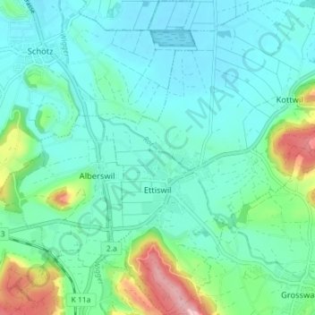
Name: Ettiswil topographic map, elevation, terrain.
Location: Ettiswil, Lucerne, Suisse (47.12910 8.00152 47.17761 8.06130)
Average elevation: 536 m
Minimum elevation: 496 m
Maximum elevation: 687 m
Thank you for supporting this site ❤️
Make a donation
Make a donation
Other topographic maps
Click on a map to view its topography, its elevation and its terrain.
Thank you for supporting this site ❤️
Make a donation
Make a donation